


Sail Expert
Sailing App
Descrizione di Sail Expert: Sailing App
L'applicazione Sailing Expert, un coltellino svizzero per velisti, supporta la navigazione, la regata, aiuta i velisti a tenere il diario di bordo, mostra le previsioni del tempo, tiene il registro di manutenzione per diverse barche e altro ancora.
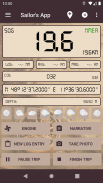
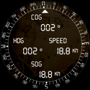
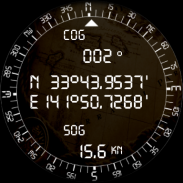
I sensori del dispositivo vengono utilizzati per riempire il registro (posizione, COG, SOG, temperatura, pressione).
Se un provider WiFi NMEA è disponibile tramite WiFi, verranno invece utilizzati i sensori dell'imbarcazione. Sono supportati sia TCP che UDP.
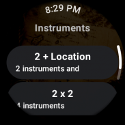
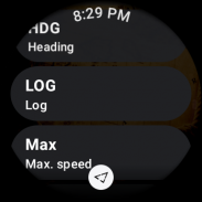
Questa app supporta l'app di accompagnamento dell'orologio Wear OS che mostra gli strumenti sull'orologio.
Consulta
https://sail.expert/permissions
per sapere come questa app utilizza le autorizzazioni.
Frasi NMEA supportate:
• GGA, GLL, GNS, RMC - Posizionamento
• HDG, HDM, HDT, VHW - Direzione
• VBW, VHW, VTG - Rotta, velocità
• VLW - Registro di viaggio
• DBT, DBP - Profondità
• RPM - Giri motore
• MDA, MHU, MMB, MTA, MTW, MWD, MWV, VWR, VWT - Meteo/meteo
Navigazione
L'applicazione ti dirà il percorso target o ti avviserà se sei fuori rotta, calcolerà la distanza rimanente e l'orario di arrivo stimato (ETA).
• Rotte: durante la navigazione puoi utilizzare le rotte per navigare
• Target: fissa un rilevamento concreto o un punto di interesse target (POI) verso il quale vuoi navigare
• Passaggio: l'applicazione ti aiuta a pianificare un passaggio utilizzando un metodo grafico distanza-tempo
• Linea di partenza: in regata l'applicazione ti aiuta ad attraversare la linea di partenza in tempo e con la velocità ottimale
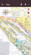
Grafici
• I dati della mappa del progetto OpenSeaMap o NOAA RNC sono disponibili nell'applicazione per l'utilizzo offline
• I server di mappe personalizzati possono essere utilizzati con questa applicazione (ad es. mappe OpenStreet)
• I file MBTiles locali possono essere importati
• Le mappe scansionate possono essere importate, calibrate e impostate come sorgente cartografica
Previsioni meteo
Le previsioni meteorologiche globali (NOMADS GFS, DWD ICON Global e località selezionate) possono essere scaricate nell'app e utilizzate durante il viaggio.
Viaggi
• I viaggi possono essere preparati in anticipo con il supporto del semplice check-in e check-out per il trasferimento in barca
• I viaggi o le loro parti possono essere esportati in CSV, GPX e PDF direttamente dall'app
• I dati registrati possono essere facoltativamente sincronizzati con
https://sail.expert
• Il viaggio può essere condiviso tra dispositivi utilizzando la connessione P2P tramite WiFi
Altro
• Mentre sei all'ancora, l'app monitora la tua posizione e ti avvisa se deviato fuori dall'area impostata. Tale area può essere configurata come posizione e raggio o insieme di punti (poligono). Un secondo dispositivo può essere configurato per monitorare l'allarme dell'ancora a distanza.
• Espressioni semplici impostabili come allarmi su diversi strumenti
• Funzione di suggerimento di contatto opzionale quando si aggiungono/modificano persone nell'app (è necessaria l'autorizzazione per leggere i contatti)
Funzionalità e funzioni richieste dagli utenti in base al feedback dei nostri utenti
• Esportazione PDF
• Pianificatore di passaggio (grafico distanza-tempo)
• Fissaggio manuale della posizione
• Allenatore di velocità udibile
• Registro di manutenzione per barche
• Allarme ancora
• Trasferimento dati P2P tra dispositivi
• Guida in-app (solo EN)
• Ripristinare il backup
Altre caratteristiche:
• NMEA tramite Wi-Fi
• Previsioni del tempo
• Profilo del vento
• Sovrapposizioni di mappe nautiche
• Navigazione
• Mappe OpenSea
• Uomo in mare
• Linea di partenza
• Unità (metriche, imperiali, ...)
• GPX, esportazione CSV
• Strumenti configurabili
Questa applicazione non richiede una connessione a Internet né alcuna registrazione per la sua funzione di base.
Incoraggiamo i nostri utenti a presentare segnalazioni se l'applicazione si comporta male o si arresta in modo anomalo.
Le segnalazioni possono essere inoltrate anche tramite e-mail a info@sail.expert.
Molte grazie per tutte le segnalazioni e suggerimenti!
Vedi
https://sail.expert
per maggiori dettagli.
Alcune icone provengono da:
- Icons8.com (https://icons8.com/)
- MatWeather (http://prithusworks.blogspot.com/2015/07/matweather-material-weather-icon-set.html)
- Raccolta di icone delle mappe (https://mapicons.mapsmarker.com)
Sail Expert: Sailing App - Versione 7.0.295
(19-02-2025)Sail Expert: Sailing App - Informazioni APK
Versione APK: 7.0.295Pacchetto: com.poterion.logbookUltima versione di Sail Expert: Sailing App
Altre versioni


 4.35
4.35


App nella stessa categoria

Potrebbe piacerti anche...


